


Travels for Engineers to Yosemite National Park
- dayhahaha
- Apr 7, 2022
- 7 min read
By David H. Allen
Overview
I just finished up my eighteenth trip to Yosemite National Park. That may not sound like a whole lot - many Californians visit Yosemite once or twice every year – but for someone from Texas it is quite a lot! Over the span of the last thirty-five years, I’ve been fortunate to have had numerous opportunities to visit Northern California, and I made the most of them by visiting Yosemite whenever possible. I’ve day-tripped, camped out, and stayed in hotels just about everywhere possible in and around the park. As a result, I can say this with assurance – John Muir was right when he maintained that Yosemite is one of the most gorgeous places on our planet ever created by Mother Nature.
For those of you who are technically minded, Yosemite lies on the western slopes of the Rocky Mountains, having been pushed upwards millions of years ago by the Pacific Plate sliding under North America. This caused weaknesses in the Earth’s crust that led to volcanic activity, some of which created granite domes resulting from molten lava that solidified before they reached the Earth’s surface. Several of these massive domes dot Yosemite valley, and recent ice ages have scoured the walls of the valley, creating El Capitan, and in one case shearing off a portion of the enormous dome that is now called Half Dome. Subsequent erosion caused by rainfall and melting snow filled in and levelled the valley, which is fed by the Merced River. Thus, there are incredible wonders nearly everywhere one gazes, thereby reminding us that the greatest engineer of all is Nature herself. Below I will mention a few of my favorite sites within this, my favorite natural setting on Earth.
Historic Sites for Engineers
Half Dome
El Capitan notwithstanding, my personal favorite site in Yosemite is Half Dome (Fig. 1). That may be at least in part due to the fact that I have been on top of Half Dome three times. All three times I came up from Quarter Dome (the easy route – ha!), but on my first arrival up top I crept over to the edge of the vertical face, peered downward, and perhaps a hundred feet down a climber was inching his way UP the front face!!!

To scale Half Dome (by any route whatsoever), you will have to apply perhaps a year in advance and be selected in the lottery in order to be approved to do this extremely punishing hike. And if you are selected, start preparing immediately, because this is one of the most challenging hikes I’ve ever done in my life. And if you take the Quarter Dome route, be prepared for the cables at the pinnacle of Half Dome – they are not only challenging, they can be terrifying for those with acrophobia! Still, the view from the summit is perhaps the most impressive I’ve ever had the good fortune to observe (Fig. 2).

El Capitan
This massive granite monolith is said to be the largest in the world. On a good day, you may be fortunate enough to see climbers heading up the front face. In the old days, parachutists would jump into the valley from the precipice, but alas, due to some unfortunate landings parachuting from El Capitan is normally prohibited.
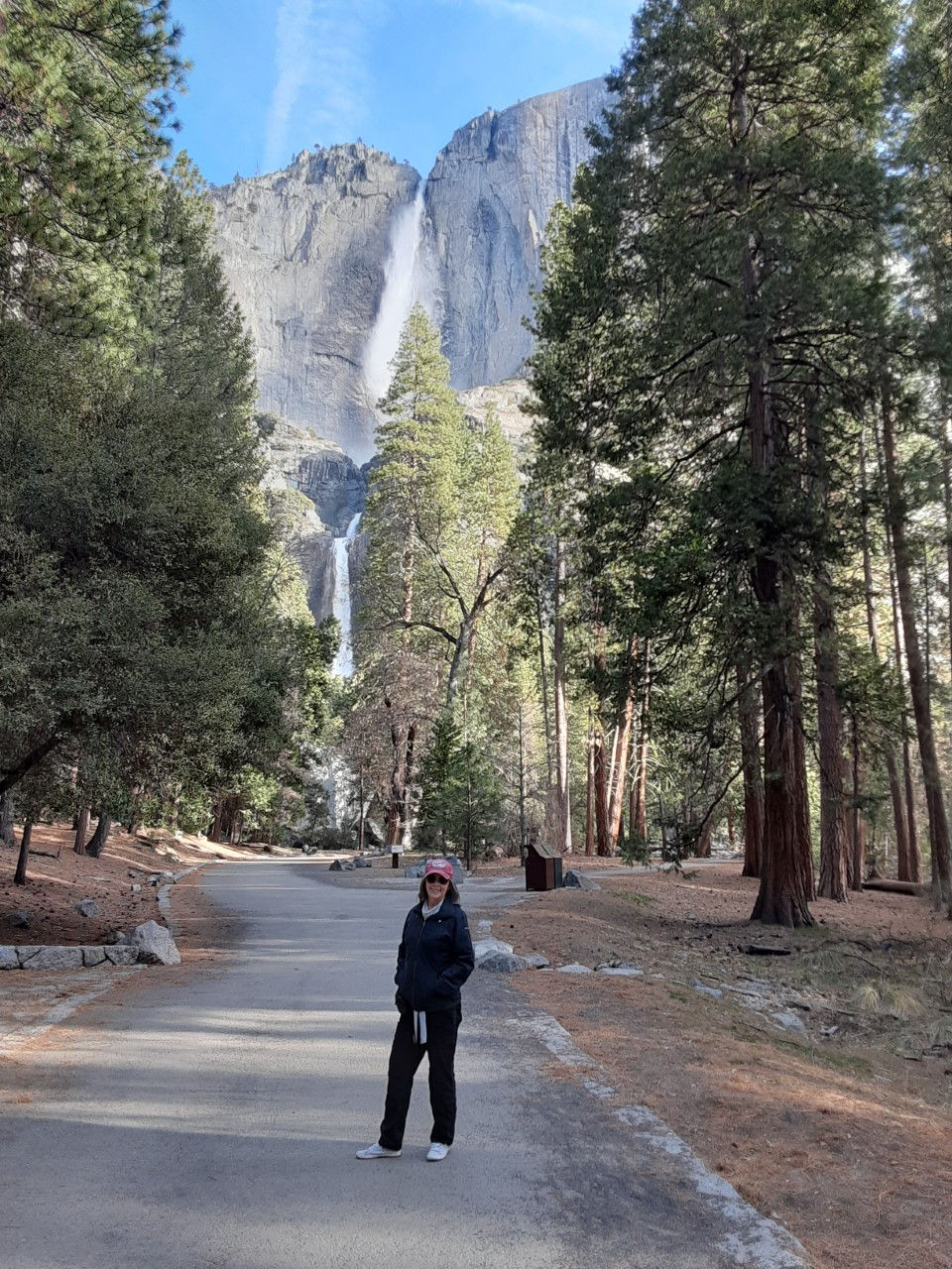
Yosemite Falls
Yosemite Falls is actually two separate waterfalls stacked vertically, but together they comprise the tallest falls in North America (Fig. 3). In the springtime water pours over the top as a prodigious rate, and in winter much of the water freezes in the cold air and creates a massive snow and ice castle on the rock face. There is a hike from the valley (3.6 miles one-way) that will take you to the top, where the view is spectacular, but beware: it’s a tough hike! Note also the Lost Arrow Spire to the right of the upper fall, which climbers often ascend.
Glacier/Washburn Points
Perhaps the best view of Yosemite Valley that can be reached by car is located at the dual sites of Glacier and Washburn Points. These can also be reached from the valley floor by the strenuous trail called Four Mile Trail, but beginners should avoid this tough trail.
Sentinel Dome
For those who are not inclined to attempt the hike to Half Dome, I recommend the Sentinel Dome hike. At over 8,000 feet, it will provide a fabulous view of the valley below.
Vernal/Nevada Falls
My favorite short hike in all of Yosemite is the Mist Trail, which takes you up to the top of Vernal Fall (Fig. 4). At 1.5 miles in length, it has quite a bit of elevation, thus nonetheless making it somewhat challenging. This is also the start of the Half Dome trail, and for those who don’t want to go all the way up to Half Dome, but are nonetheless underwhelmed by the hike to Vernal Fall, you can continue up for another two miles to the top of Nevada Fall, which is quite spectacular in its own right.

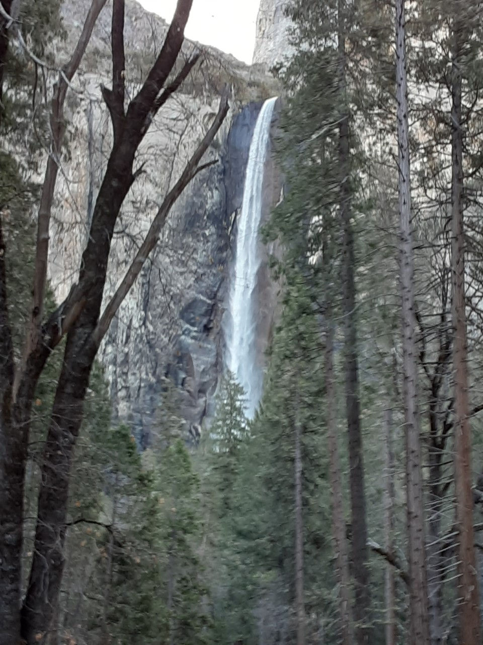
Bridal Veil Fall
Bridal Veil Fall (Fig. 5) is the first fall you will encounter on entering the valley from the west, and sometimes it is absolutely gorgeous (especially at sunset!). Unfortunately, during the late summer months it can dwindle quite a bit, but when it is flowing just the right amount, the wispy sheets of water that float into the valley provide visual confirmation of its whimsical cognomen. Nonetheless, Bridal Veil is the only one of the major falls into the valley that flows year-round.
The Ahwahnee Hotel
Although it is not part of the nature of Yosemite, I include the Ahwahnee Hotel (Fig. 6) here because of its historical significance. One of the first U.S. National Park hotels, it was constructed in 1927, and despite its now somewhat dated appearance it holds great attraction for the engineer in me due to the intricate structural interplay between huge timbers and (concrete) simulated wooden beams that are visible throughout the hotel. Though expensive (and quite difficult to book), I’ve stayed there quite a few times and I can say that a stay in the Ahwahnee is well worth the investment.
Taft Point
Of all the hikes in Yosemite, this hike may just provide the biggest bang for your buck. To get there you will have to take the Glacier Point Road from the main valley. About five miles after the turnoff from the Wawona Road, you will see a parking lot on the left indicating the Taft Point hike. This hike is only about a mile in length, and it is relatively flat, but a fabulous treat emerges right at the end of the hike, for you will arrive on the south lip of the valley, staring directly down into what are the largest cracks I’ve ever laid eyes on in my entire life (and I study fracture mechanics). Thus, this hike is a fabulous treat for the curious and technically minded.

North Dome
North Dome sits on the north side of the valley close to the Ahwahnee Hotel and directly across from Half Dome. As such, it offers what in my mind is the best view of Half Dome in all of Yosemite. It can be can be reached by the main valley, but I prefer the hike that starts from the Tioga Road. It is lengthy (about twelve miles roundtrip), but it traverses some of the remote high country where few others hike. The view from the top of North Dome is one of the best in all of Yosemite, and while you’re standing atop it you can imagine the forces of nature that created it long ago.
The Tioga Road
For those of you who have time for a lengthy car hike, the Tioga Road offers a worthwhile adventure. The road normally opens in early May and remains open until mid-October each year. Commencing from the West end of the park, the road traverses the highlands Eastward on the north side of the main valley. Along the way there are several campgrounds, plenty of opportunities for great hikes (including May Lake, Tuolumne Meadows, Yosemite Falls, and North Dome), but for me the best thing to see is at the eastern end of the road – Tioga Pass. This massive pass is quite impressive, and on a good day you may even spot bighorn sheep on the upper slopes. At the eastern end you come to the small town of Lee Vining, and if you are still not sated, you can either travel north to the rustic and now deserted mining town of Bodie, or south to the White Mountains, where Ansel Adams took some fabulous photos (in addition to those he took in Yosemite).
The Mariposa Grove
In the far southern portion of Yosemite National Park there is a grove of Giant Sequoia trees. It can be a bit of a hassle getting there, but it is well worth the effort. You will need to drive from the main valley approximately 35 miles along a winding park road, then park near the Fresno entrance and take a bus to the trailhead. From there it is about a two-mile hike through the forest to the Mariposa Grove (Fig. 7). Along the way you will also be treated to the giant Sequoia tree named the Grizzly Giant, estimated to be 2,700 years old and one of the largest trees on Earth.

Summation
It will take you as much as a week to see all of the above important sites in Yosemite, depending on your physical stamina and the crowds during your visit. Although many of the sites mentioned here are closed in winter, Yosemite in winter is actually quite a treat, and the crowds are much smaller at that time of year. And while every site mentioned above will be accessible in summer, be prepared for the most crowded U.S. National Park I have ever encountered.
I hope these tidbits are of use to you for your first-ever (or next) visit to Yosemite. In future blogs I will give more detailed reviews of some of my other favorite U.S. destinations. Until then, please feel free to contact me if you have questions (drdavidhallen@gmail.com).
Note: All photos included in this blog were taken by me.


Comments